National Aeronautics and Space Administration
Goddard Space Flight Center
Multi-decadal Sulfur Dioxide Climatology from Satellite Instruments.
Search:
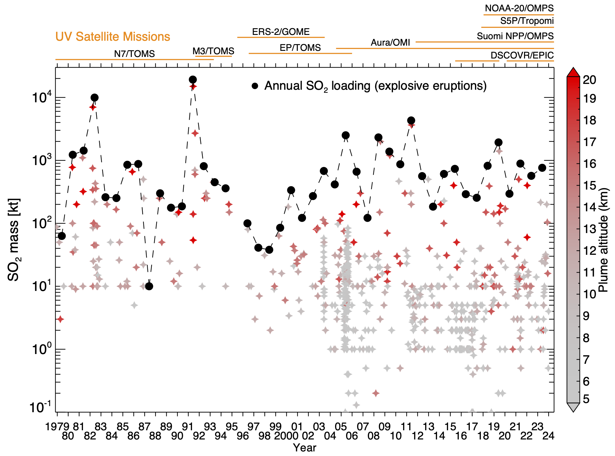
SO2 emissions by explosive volcanic eruptions: 1979-2024.
Sulfur Dioxide (SO2) V2 catalogue: 2005-2022
A reference for more info about the V2 catalogue
Time series plots for 40 regions of the world. Updated daily. GRAY means Oil and Gas, RED means Power Plant, BLUE means Smelter, and ORANGE is a Volcano.
TOMS images (1979-2005) | AIRS images (2003-present) | OMI images (2004-present) | OMPS images (May 2012-present)
Global monthly OMI Boundary Layer SO2 maps
Global monthly OMPS Boundary Layer SO2 maps
L2 OMPS SO2 Data
Active Volcanism
Earthquakes, eruptions & emissions from the Global Volcanism Program (GVP) at the Smithsonian Institution.
Each week, Smithsonian's GVP publishes a report of new volcanic activity.
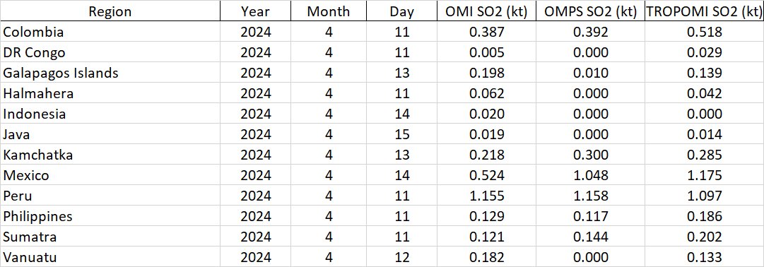
The SO2 data collected by AURA/OMI and Suomi NPP/OMPS for the new activity this week are shown below.
Week of 10 - 16 Apr 2024
Colombia - Ruiz: OMI OMPS TROPOMI
DR Congo - Nyamuragira & Nyiragongo: OMI OMPS TROPOMI
Galapagos Islands - Fernandina: OMI OMPS TROPOMI
Halmahera - Dukono: OMI OMPS TROPOMI
Indonesia - Lewotolok: OMI OMPS TROPOMI
Java - Semeru: OMI OMPS TROPOMI
Kamchatka - Klyuchevskoy & Shiveluch: OMI OMPS TROPOMI
Mexico - Popocatepetl: OMI OMPS TROPOMI
Peru - Sabancaya: OMI OMPS TROPOMI
Philippines - Canlaon & Taal: OMI OMPS TROPOMI
Sumatra - Marapi: OMI OMPS TROPOMI
Vanuatu - Aoba & Yasur: OMI OMPS TROPOMI
Summary of Preliminary Tonnage estimates
 Past Weeks Reports
Time series plots for 35 regions of the world. Updated daily.
Week of 10 - 16 Apr 2024
Colombia - Ruiz: OMI OMPS TROPOMI
DR Congo - Nyamuragira & Nyiragongo: OMI OMPS TROPOMI
Galapagos Islands - Fernandina: OMI OMPS TROPOMI
Halmahera - Dukono: OMI OMPS TROPOMI
Indonesia - Lewotolok: OMI OMPS TROPOMI
Java - Semeru: OMI OMPS TROPOMI
Kamchatka - Klyuchevskoy & Shiveluch: OMI OMPS TROPOMI
Mexico - Popocatepetl: OMI OMPS TROPOMI
Peru - Sabancaya: OMI OMPS TROPOMI
Philippines - Canlaon & Taal: OMI OMPS TROPOMI
Sumatra - Marapi: OMI OMPS TROPOMI
Vanuatu - Aoba & Yasur: OMI OMPS TROPOMI
Summary of Preliminary Tonnage estimates
Past Weeks Reports
DR Congo - Nyamuragira & Nyiragongo: OMI OMPS TROPOMI
Galapagos Islands - Fernandina: OMI OMPS TROPOMI
Halmahera - Dukono: OMI OMPS TROPOMI
Indonesia - Lewotolok: OMI OMPS TROPOMI
Java - Semeru: OMI OMPS TROPOMI
Kamchatka - Klyuchevskoy & Shiveluch: OMI OMPS TROPOMI
Mexico - Popocatepetl: OMI OMPS TROPOMI
Peru - Sabancaya: OMI OMPS TROPOMI
Philippines - Canlaon & Taal: OMI OMPS TROPOMI
Sumatra - Marapi: OMI OMPS TROPOMI
Vanuatu - Aoba & Yasur: OMI OMPS TROPOMI
Long-term volcanic SO2 emissions.

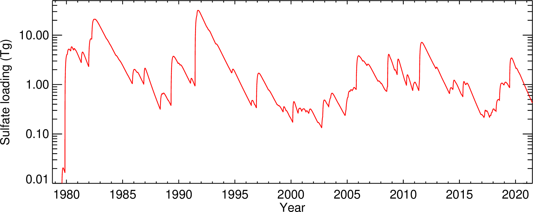
The SO2 mass for all significant explosive eruptions in our database (VEI 3+) was converted to sulfate mass in this plot using a typical SO2/sulfate mass ratio (assuming complete conversion of SO2 to sultate aerosol with composition 75 wt% H2SO4 - 25 wt% H2O). To simulate the decay of sulfate aerosol mass with time we assumed a fixed, latitude-dependent e-folding time. |
- Privacy Policy & Important Notices
- Contact Us (Nickolay.A.Krotkov AT nasa.gov)

- NASA Official: Nickolay A. Krotkov (Nickolay.a.krotkov AT nasa.gov)
- Web Content: Keith D. Evans (UMBC/GESTAR II) (evans AT umbc.edu)
- Last Updated: 2024-04-22